| |
| West Cork; Bantry Bay |
| |
 |
|
 |
|
 |
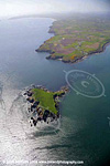
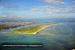
EIBN - Bantry
Bay
File # dr_f2_1449 |
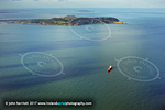
|
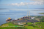
Oil terminal, Bantry Bay
File
# d0457 |
|
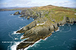
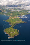
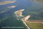
Sheeps
Head, Bantry Bay
File # dr_f2_2896 |
| |
| More West Cork Bays |
| |
 |
|
 |
|
 |
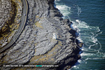
Dunlough Bay to left
& Mizen Head
File # d0381 |
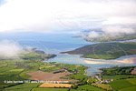
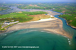
|
head of Dunmanus Bay
Durrus at low tide
File # d0447 |
|
Dirk Bay to right &
Galley Head
File # d0176 |
| |
 |
|
 |
|
 |
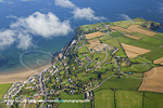
| Clonakilty
Bay and Ring
File # dr_f2_1597 |
|
Roaringwater Bay
File # dr_f4_1687 |
|
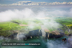
Rennies Bay & Coastal
fog
File # dr_f3_1547 |
| |
 |
|
 |
|
 |
Old
Head of Kinsale &
Holeopen Bays
File # dr_f2_0703 |
|
Old Head,
Holeopen Bays
steeper angle
File # dr_f4_3430 |
|
Roaringwater Bay &
Sherkin Island
File # d0256 |
| |
 |
|
 |
|
 |
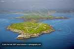
Heir Island,
Roaringwater Bay
File
# dr_f4_6325 |
|
Inchydoney, Clonakilty Bay
File # dr_f2_0597 |
|
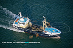
Fishing
trawler on
Courtmacsherry Bay
File # dr_f2_0692 |
| |
| Waterford Bays |
| |
 |
|
 |
|
 |
Clonea Bay, Ballyvoyle Hd. Waterford
File # dr_f4_3086 |
|
Ardmore Bay, Waterford
File # dr_f3_7048 |
|
Dunmore Bay
File # dr_f3_6931 |
| |
| East Cork Bays |
 |
|
 |
|
 |
Ballycotton Bay top right
File # d1367 |
|
Youghal Bay view west to
Ballycotton Bay
File # d1313 |
|
Youghal Bay and Beach
overlooked by hotel
File # d1257 |
| |
 |
|
|
|
|
Trawler at Youghal Bay
File
# dr_f2_7128 |
|
|
|
|
| |
| |
| Dublin Bay |
| |
 |
|
 |
|
 |
Dublin Bay and Howth Head
File # 1dsm3_f6_2532 |
|
Irishtown,Poolbeg
and Dublin Bay
File # dr_f3_8991 |
|
Scotsmans Bay and the
40ft Sandycove Co Dublin
File
# f1_7424 |
| |
 |
|
 |
|
 |
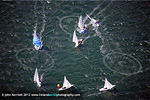
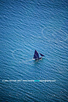
Leisure activity; Sailing,
Dublin Bay
File # 1dsm3_f2_5555 |
|
Portmarnock Strand and Golf
links. Dublin Bay,
from
Dublin Port entrance
File # dr_f4_7329 |
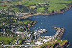
|
Dun
Laoghaire, Co. Dublin
File # 1dsm3_f1_0083 |
| |
| Bays in County Kerry |
| |
 |
|
 |
|
 |
Shore of Ballinskelligs Bay
File # dr_f4_6505 |
|
Dingle Bay detail, Rossbeigh
File # dr_f4_2575 |
|
Tarbert &
Glencooslagh Bay
File # dr_f3_5467 |
| |
 |
|
 |
|
 |
Brandon Bay
File # dr_f3_5623 |
|
Derrynane Bay, Ring of Kerry
File # dr_f4_6478 |
|
Tralee Bay
File # dr_f4_2487 |
| |
Kenmare Bay
According to maps this is the Kenmare River, although most people would know it as Kenmare Bay.
The following few images will give some sense of the location of this body of water separating the Beara and Iveragh peninsulas.
|
 |
|
 |
|
 |
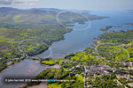
Kenmare
aerial view of Bay
File # dr_f2_1388 |
|
Kenmare
bay from Cessna
File # dr_f2_1405 |
|
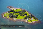
Dinish
Island, Kenmare Bay
File # dr_f2_1398 |
| |
| Bays in County Clare |
| |
 |
|
 |
|
 |
Doughmore Bay, Co Clare
File # 1dsm_f4_0968 |
|
Ballymacrinan Bay and Money Point Power Stn.
File # dr_f3_5473 |
|
Ross Bay Co Clare
File # dr_f5_4994 |
| |
| Bays in County Mayo |
| |
 |
|
|
|
|
River
Moy & Killala Bay, Mayo
File
# dr_f3_2902 |
|
|
|
|
| |
| Bays in County Galway |
| |
 |
|
 |
|
 |
Spiddal, overlooking
Galway Bay
File # dr_f2_3679 |
|
Dogs Bay detail, Co Galway
File # dr_f2_3728 |
|
Galway
Hooker, Galway Bay
File # dr_f2_3735 |
| |
| |
 |
|
 |
|
|
Roundstone Bay Co Galway
File # dr_f2_3692 |
|
Black Head Lighthouse
overlooking Galway Bay
File # dr_f7_9875 |
|
|
| |


